More areas under wind signals as 'Egay' further intensifies
MANILA, Philippines — More areas in Luzon and Visayas were placed under Tropical Cyclone Wind Signals due to Egay as Typhoon Egay (international name: Doksuri) further strengthened, the state weather bureau said Monday.
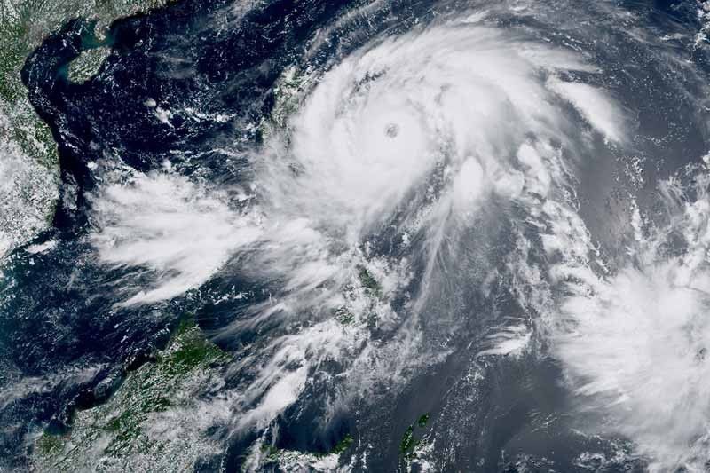
Egay was last spotted 525 kilometers east of Baler in Aurora with peak winds of 150 kph near the center and gusts of up to 185 kph. It was heading westward slowly.
PAGASA said the country’s fifth cyclone may continue to intensify and reach super typhoon category by late Tuesday and early Wednesday.
The following areas were placed under wind signals:
Wind Signal No. 2
Luzon
- Catanduanes
- Central and eastern portion of Isabela (Palanan, Dinapigue, Santo Tomas, Cabagan, Tumauini, San Pablo, Maconacon, Santa Maria, Quezon, Delfin Albano, Mallig, Quirino, Roxas, Burgos, Ilagan City, Divilacan, San Mariano, Gamu, Naguilian, Benito Soliven, City of Cauayan, Reina Mercedes, Luna, San Manuel, Aurora, Cabatuan, San Guillermo, Echague, Jones, Angadanan, Alicia, San Mateo, San Isidro, San Agustin)
- Eastern portion of Albay (Rapu-Rapu, Bacacay, City of Tabaco, Malilipot, Malinao, Tiwi)
- Eastern portion of Camarines Sur (Caramoan, Presentacion, Garchitorena, Lagonoy, San Jose, Sagñay)
- Northern portion of Aurora (Dilasag, Casiguran, Dinalungan)
- Eastern portion of Quirino (Maddela)
- Eastern and central portion of Cagayan (Santa Ana, Gonzaga, Lal-Lo, Santa Teresita, Buguey, Gattaran, Baggao, Peñablanca, Amulung, Alcala, Iguig, Tuguegarao City, Solana, Enrile)
- Northern portion of Camarines Norte (Calaguas and Maculabo Islands)
Visayas
- Northeastern portion of Northern Samar (Laoang, Palapag)
Minor to moderate impacts from gale-force winds are possible within any of the areas where Wind Signal No. 2 are in effect.
Wind Signal No. 1
Luzon
- Sorsogon
- Rest of Albay
- Rest of Camarines Sur
- Rest of Camarines Norte
- Rest of Isabela
- Rest of Cagayan including Babuyan Islands
- Apayao
- Abra
- Kalinga
- Mountain Province
- Ifugao
- Rest of Quirino
- Nueva Vizcaya
- Batanes
- Masbate including Ticao Island, Burias Island
- Quezon including Polillo Islands,
- Rest of Aurora
- Benguet
- Ilocos Sur
- Ilocos Norte
- La Union
- Nueva Ecija
- Pangasinan
- Tarlac
- Zambales
- Bulacan
- Pampanga
- Bataan
- Marinduque
- Cavite
- Metro Manila
- Rizal
- Laguna
- Eastern and central portion of Romblon (Banton, Corcuera, Romblon, Magdiwang, Cajidiocan, San Fernando)
- Northern and central portion of Batangas (Calaca, Cuenca, Taysan, Lian, Tuy, Balayan, Talisay, Padre Garcia, Agoncillo, Santo Tomas, San Jose, Lemery, Lipa City, Ibaan, City of Tanauan, Mataasnakahoy, Alitagtag, Balete, Nasugbu, San Juan, San Nicolas, Rosario, Laurel, Santa Teresita, Taal, Malvar)
Visayas
- Eastern Samar
- Rest of Northern Samar
- Samar
- Biliran
- Northern and central portion of Leyte (Tunga, Pastrana, San Miguel, Mahaplag, Matag-Ob, Tolosa, Palo, Calubian, Leyte, Mayorga, Julita, Carigara, Babatngon, Dagami, Jaro, Abuyog, San Isidro, Santa Fe, Albuera, Villaba, La Paz, Palompon, Macarthur, Tabontabon, Tanauan, Merida, Ormoc City, Isabel, Javier, Dulag, Capoocan, Alangalang, City of Baybay, Burauen, Tabango, Tacloban City, Kananga, Barugo)
- Northern portion of Cebu (Daanbantayan, Medellin) including Bantayan Islands, Camotes Islands
Minimal to minor impacts from strong winds are also possible within any of the areas where Wind Signal No. 1 is hoisted.
The state weather bureau said that Wind Signal No. 4 or 5 will be the highest wind signal that may be raised.
What to expect
According to PAGASA, the following regions are expected to experience heavy rainfall:
Monday to Tuesday noon
- 50 to 100 millimeters: Cagayan, Catanduanes, Camarines Sur, Camarines Norte, and the northern portion of Sorsogon
Tuesday noon to Wednesday noon
- Above 200 mm: Batanes, Cagayan, Ilocos Norte, Ilocos Sur, northern portion of Apayao, Abra, and the northern portion of La Union
- 100 to 200 mm: the northern and eastern portion of Isabela, the rest of Apayao, the rest of La Union, Mt. Province, Benguet, and the western portion of Pangasinan
- 50 to 100 mm: the rest of Cordillera Administrative Region, the rest of Pangasinan, and Zambales
Wednesday noon to Thursday noon
- Above 200 mm: Batanes, Babuyan Islands, Ilocos Norte, the northwestern portion of Abra
- 100 to 200 mm: The northern portion of mainland Cagayan, Apayao, the rest of Abra, and Ilocos Sur
- 50 to 100 mm: The rest of mainland Cagayan, Kalinga, the western portion of Mountain Province, Benguet, La Union, and Pangasinan
PAGASA warned that heavy rain may trigger floods and landslides, especially in areas that are highly or very highly susceptible to these hazards, and in localities that experienced considerable amounts of rainfall for the past several days.
Egay may also enhance the southwest monsoon, which will dump occasional rain to the western portions of Central Luzon, Southern Luzon, and Visayas in the next three days.
The cyclone and the enhanced southwest monsoon may also bring gusty conditions over the following areas:
Monday
- Rest of Visayas and MIMAROPA
- Northern portions of Zamboanga Peninsula, Northern Mindanao, and Caraga
Tuesday
- Rest of Luzon and Visayas
- Zamboanga Peninsula
- Basilan
- Sulu
- Tawi-Tawi
- Northern portion of Northern Mindanao and Dinagat Islands.
Wednesday
- Visayas and the rest of Luzon
PAGASA also warned that there is a “minimal to moderate risk” of storm surge of up to 2 meters in height, which may cause flooding in the low-lying and exposed coastal areas of Batanes, Cagayan, Ilocos Norte and Isabela.
Egay is expected to cross the Luzon Strait, and make landfall or pass very close to the Babuyan Islands-Batanes area between late Tuesday and Wednesday afternoon. Egay may exit the Philippine Area of Responsibility on Thursday.
‘It must be emphasized that further shift in the track forecast closer to Luzon remains a possibility due to the persistence of the ridge of high pressure north of the typhoon,” PAGASA said, noting that a landfall over the northeastern portion of mainland Cagayan is not ruled out.
Forecast positions
- July 24, 2023 8:00 p.m. - 425 km east of Baler, Aurora
- July 25, 2023 8:00 a.m. - 320 km east of Tuguegarao City, Cagayan
- July 25, 2023 8:00 p.m. - 180 km east of Aparri, Cagayan
- July 26, 2023 8:00 a.m. - Over the coastal waters Calayan, Cagayan
- July 26, 2023 8:00 p.m. - 145 km west Southwest of Basco, Batanes
- July 27, 2023 8:00 a.m. - 245 km west of Itbayat, Batanes (outside PAR)
- July 28, 2023 8:00 a.m. - 595 km northwest of Itbayat, Batanes (outside PAR)
- July 29, 2023 8:00 a.m. - 1,020 km northwest of extreme Northern Luzon or in the vicinity of Jiangxi, China (outside PAR)


- Latest
- Trending