


'Egay' makes another landfall; 'violent' conditions expected in northern Luzon
MANILA, Philippines (Updated, 2:15 p.m.) — The country’s weather agency warned that “violent and life-threatening” conditions may continue in parts of northern Luzon after Typhoon Egay (international name: Doksuri) made another landfall Wednesday morning.
In its 2 p.m. bulletin, PAGASA said rough conditions are expected in Babuyan Islands, the northwestern portion of mainland Cagayan, and northern portions of Apayao, and Ilocos Norte in the next six hours.
Egay was last spotted over the coastal waters of Calayan in Cagayan after making a landfall in Dalupiri Island, which is home to over 600 residents.
The typhoon had peak winds of 175 kilometers per hour near the center and gusts of up to 240 kph. PAGASA said that Egay was expected to weaken slowly.
It was moving northwest at 10 kph.
The state weather bureau hoisted tropical cyclone warning signals in the following areas:
Signal No. 4
- northern portion of Cagayan (Santa Ana, Gonzaga, Claveria, Sanchez-Mira, Pamplona, Abulug, Ballesteros, Aparri, Buguey, Santa Teresita, Camalaniugan, Santa Praxedes) including Babuyan Islands
- northern portion of Apayao (Calanasan, Luna, Santa Marcela)
- northern portion of Ilocos Norte (Burgos, Bangui, Dumalneg, Pagudpud, Adams, Pasuquin, Vintar, Bacarra)
Significant to severe threats to life and property are expected in these areas.
Signal No. 3
- Batanes
- rest of Cagayan
- rest of Apayao
- northern portion of Kalinga (Rizal, Pinukpuk, Balbalan)
- northern portion of Abra (Tineg, Lagayan, Lacub, Danglas, Bangued, La Paz, San Juan, Dolores, Tayum, Lagangilang, Malibcong, Licuan-Baay, Peñarrubia, Pidigan, Langiden, San Quintin, Bucay, San Isidro, Sallapadan)
- rest of Ilocos Norte
- northern portion of Ilocos Sur (Magsingal, San Juan, Cabugao, Sinait, San Vicente, Santo Domingo, San Ildefonso, Bantay, Santa Catalina, City of Vigan, Caoayan, Santa, Nagbukel, Narvacan)
Moderate to significant impacts from storm-force winds may be experienced within these areas.
Signal No. 2
- Isabela
- rest of Kalinga
- Mountain Province
- Ifugao
- Benguet
- rest of Abra
- rest of Ilocos Sur
- La Union
- northern and western portions of Pangasinan (Sison, San Jacinto, Pozorrubio, San Fabian, Dagupan City, Calasiao, Binmaley, Lingayen, Bugallon, Mabini, Labrador, Infanta, Dasol, Burgos, Agno, City of Alaminos, Sual, Anda, Bolinao, Bani, San Manuel, Binalonan, Laoac, Manaoag, Mangaldan, Mapandan, Santa Barbara, San Nicolas)
Minor to moderate impacts from gale-force winds are possible within any of these areas.
Signal No. 1
- Aurora
- Quirino
- Nueva Vizcaya
- rest of Pangasinan
- Nueva Ecija
- Tarlac
- Pampanga
- Bulacan
- Zambales
- Bataan
- Metro Manila
- Rizal
- Cavite
- Laguna
- northern portion of Batangas (Talisay, City of Tanauan, Santo Tomas, Balete, Malvar, Lipa City)
- northern and central portions of Quezon (Pitogo, Calauag, Infanta, Lopez, Guinayangan, Unisan, Plaridel, Quezon, Alabat, Padre Burgos, Mauban, General Nakar, Perez, Agdangan, Gumaca, Atimonan, Real, Tagkawayan, Lucena City, Pagbilao, Lucban, Sampaloc, City of Tayabas, Dolores, Sariaya, Candelaria, Tiaong, San Antonio) including Polillo Islands
- northern portion of Camarines Norte (Santa Elena, Vinzons, Labo, Capalonga, Paracale, San Vicente, Talisay, Jose Panganiban)
Minimal to minor impacts from strong winds are possible in these areas.
At least one was reportedly killed and 180,000 people were affected by Egay and the southwest monsoon, the National Disaster Risk Reduction and Management Council reported.
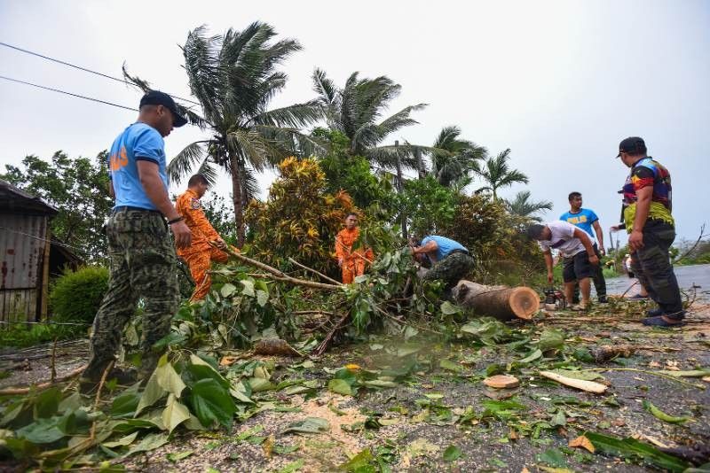
Egay toppled trees, knocked out power poles and triggered floods as it battered northern Luzon.
Heavy rain, violent winds
According to the state weather bureau, heavy rain from Egay will affect the following areas in Luzon on Wednesday:
- Above 200 millimeters: northwestern portion of Cagayan including Babuyan Islands, and Ilocos Norte
- 100 to 200 mm: Batanes, Ilocos Sur, rest of Cagayan, Apayao, and Abra
- 50 to 100 mm: Zambales, and rest of Cordillera Administrative Region and Ilocos Region
PAGASA warned that landslides and floods are “highly likely” in areas that are very susceptible to these hazards and in areas that experienced considerable amounts of rainfall for the past several days.
The southwest monsoon enhanced by Egay will continue to dampen the western portions of central Luzon, southern Luzon and Visayas in the next three days.
Egay and the enhanced southwest monsoon will also bring gusty conditions in areas in Luzon and Visayas that are not under any wind signal.
Weather forecasters warned that storm surges of more than three meters may cause flooding in the low-lying and exposed coastal areas of Batanes, Cagayan including Babuyan Islands, Ilocos Norte, and portions of Isabela and Ilocos Sur.
They also warned that sea travel along the seaboards of Luzon and Visayas is risky for most vessels.
PAGASA noted that Egay may exhibit wobbling motion while in the vicinity of the Babuyan Island in the next six hours. It will leave the Philippine Area of Responsibility Thursday morning.
Scientists have warned that cyclones are becoming more powerful and destructive as the world becomes warmer because of climate change. The Philippines is one of the world’s most vulnerable countries to the effects of the climate crisis.
Forecast positions
- July 26, 2023 11:00 p.m. - 205 km west of Basco, Batanes
- July 27, 2023 11:00 a.m. - 295 km west northwest of Itbayat, Batanes (outside PAR)
- July 27, 2023 11:00 p.m. - 455 km northwest of Itbayat, Batanes (outside PAR)
- July 28, 2023 11:00 a.m. - 685 km northwest of Itbayat, Batanes or in the vicinity of Fujian, China (outside PAR)
- July 28, 2023 11:00 p.m. - 935 km northwest of Extreme Northern Luzon or in the vicinity of Jiangxi, China (outside PAR)
— Gaea Katreena Cabico


- Latest
- Trending


