'Egay' intensifies into super typhoon
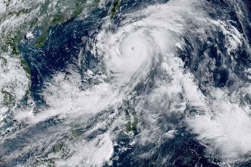
MANILA, Philippines — Cyclone Egay (international name: Doksuri) has intensified into a super typhoon Tuesday morning, threatening northern Luzon with heavy rainfall and violent winds, the national weather agency said.
According to PAGASA, Egay was last spotted 310 kilometers east of Tuguegarao City in Cagayan with peak winds of 185 kph near the center and gusts of up to 230 kph.
Scientists have warned that cyclones are becoming more powerful and destructive as the world becomes warmer because of climate change. The Philippines is one of the world’s most vulnerable countries to the effects of the climate crisis.
Moving northwestward at 10 kph, the super typhoon is forecast to make landfall or pass very close to Babuyan Islands-northeastern mainland Cagayan area between late Tuesday or Wednesday afternoon.
“Slight northward or southward shifts in this segment of the track (but within the forecast confidence cone) may result in a landfall or close approach over northern mainland Cagayan or Batanes,” PAGASA said.
PAGASA raised Tropical Cyclone Wind Signal over the following areas:
Signal No. 3
- Babuyan Islands
- Northern and eastern portions of mainland Cagayan (Santa Ana, Gonzaga, Peñablanca, Gattaran, Lal-Lo, Alcala, Santa Teresita, Buguey, Aparri, Camalaniugan, Ballesteros, Allacapan, Abulug, Claveria, Pamplona, Sanchez-Mira, Santa Praxedes, Lasam, Baggao, Amulung, Iguig)
- northeastern portion of Isabela (Divilacan, Maconacon, Palanan)
- Northern portion of Apayao (Calanasan, Luna, Santa Marcela, Flora, Pudtol)
Moderate to significant impacts from storm-force winds may be experienced in these areas.
Signal No. 2
- Batanes
- Rest of mainland Cagayan
- Rest of Isabela
- Quirino
- Northern portion of Nueva Vizcaya (Kasibu, Quezon, Diadi, Bagabag, Ambaguio, Villaverde, Solano, Bayombong)
- Rest of Apayao
- Kalinga
- Abra
- Mountain Province
- Ifugao
- Northern portion of Benguet (Bakun, Mankayan, Buguias, Kabayan, Kibungan)
- Ilocos Norte
- Ilocos Sur
- Northern and central portion of Aurora (Dilasag, Casiguran, Dinalungan, Dipaculao)
Minor to moderate impacts from gale-force winds are possible in any of these areas.
Signal No. 1
- La Union
- Pangasinan
- Rest of Benguet
- Rest of Nueva Vizcaya
- Rest of Aurora
- Zambales
- Bataan
- Nueva Ecija
- Tarlac
- Pampanga
- Bulacan
- Metro Manila
- Rizal
- Laguna
- Cavite
- Batangas
- Quezon
- Marinduque
- Camarines Norte
- Camarines Sur
- Catanduanes
- Albay
- Sorsogon
- Burias Island, and Ticao Island
- Northern Samar
Minimal to minor impacts from strong winds are possible in these areas.
PAGASA said that Wind Signal No. 4 or 5 may be the highest that will be hoisted due to Egay.
Heavy rain, storm surge
The state weather bureau said that heavy rain from Egay will affect the following areas in Luzon:
- Above 200 millimeters: Eastern portion of Babuyan Islands and the northern portions of mainland Cagayan, Apayao, and Ilocos Norte
- 100 to 200 mm: Ilocos Sur, Abra, the northern portion of La Union, the western portion of Kalinga, and the rest of Babuyan Islands, mainland Cagayan, and Apayao.
- 50 to 100 mm: Batanes, the northern and eastern portions of Isabela, the northern portion of Zambales, and the rest of Ilocos Region and Cordillera Administrative Region
PAGASA warned that forecast rainfall is generally higher in elevated or mountainous areas. Floods and rain-induced landslides are highly likely, especially in areas that are highly or very highly susceptible to these hazards and in localities that experienced considerable amounts of rainfall for the past several days.
The southwest monsoon enhanced by Egay will continue to bring occasional rain or monsoon rain over the western portions of central Luzon, southern Luzon and Visayas in the next three days.
There is also a “high risk” of storm surge, which may cause flooding in the low-lying and exposed coastal areas of Batanes, Cagayan including Babuyan Islands, Isabela and Ilocos Norte. According to PAGASA, maximum surge heights may exceed three meters.
Egay and the enhanced southwest monsoon will also continue to bring gusty conditions in areas in Luzon and Visayas that are not under any wind signal, Zamboanga Peninsula, Basilan, Sulu, Tawi-tawi, and the northern portions of Northern Mindanao and Caraga.
PAGASA said that Egay is nearing its peak intensity, and “short window of high favorable environment in the near term” will allow it to either maintain its intensity in the next 12 hours or intensify slightly.
It is expected to leave the Philippine Area of Responsibility Thursday morning.
Forecast position
- July 25, 2023 (Tuesday) 5:00 p.m. - 210 km east of Aparri, Cagayan
- July 26, 2023 (Wednesday) :00 a.m. - over the coastal waters of Calayan, Cagayan
- July 26, 2023 (Wednesday) 5:00 p.m. - over the coastal waters of Calayan, Cagayan
- July 27, 2023 (Thursday) 5:00 a.m. - 190 km west of Itbayat, Batanes
- July 27, 2023 (Thursday) 5:00 p.m. - 335 km west northwest of Itbayat, Batanes (outside PAR)
- July 28, 2023 (Friday) 5:00 a.m. - 540 km northwest of Itbayat, Batanes (outside PAR)
- July 29, 2023 (Saturday) 5:00 a.m. - 990 km northwest of extreme northern Luzon or in the vicinity of Jiangxi, China (outside PAR)


- Latest
- Trending