'Egay' continues to weaken ahead of exit from PAR
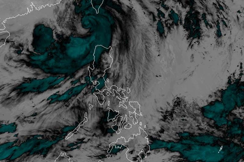
MANILA, Philippines — Typhoon Egay (international name: Doksuri) weakened further as it moved away from the Philippines Thursday morning, but the cyclone will continue to bring heavy rain and strong winds in northern Luzon.
PAGASA said in its 5 a.m. bulletin that Egay was last spotted 195 kilometers west of Basco in Batanes, with peak winds of 150 kph near the center and gusts of up to 185 kph. It was heading northwest at 15 kph.
Wind signals remained hoisted in the following areas:
Signal No. 2
- Batanes
- Cagayan including Babuyan Islands
- Apayao
- Kalinga
- Abra
- Ilocos Norte
- northern and central portion of Ilocos Sur (Magsingal, San Esteban, Banayoyo, Burgos, City of Candon, Santiago, San Vicente, Santa Catalina, Lidlidda, Nagbukel, Sinait, San Ildefonso, Galimuyod, City of Vigan, San Emilio, Cabugao, Caoayan, San Juan, Santa, Bantay, Santo Domingo, Santa Maria, Narvacan)
Minor to moderate impacts from gale-force winds are possible within any of these areas.
Signal No. 1
- Isabela
- Quirino
- Nueva Vizcaya
- Mountain Province
- Ifugao
- Benguet
- rest of Ilocos Sur
- La Union
- Pangasinan
- Aurora
- Nueva Ecija
- Tarlac
- northern portion of Zambales (Botolan, Iba, Candelaria, Cabangan, Palauig, Santa Cruz, Masinloc)
Minimal to minor impacts from strong winds are possible in these areas.
At least five people were reportedly killed and more than 328,000 were affected by Egay and the southwest monsoon, the National Disaster Risk Reduction and Management Council reported Thursday.
What to expect
Egay will continue to dampen Ilocos Norte, Ilocos Sur, La Union, Pangasinan, and the western portions of Abra and Benguet, according to PAGASA.
The typhoon still enhances the southwest monsoon, which will bring rain to the western portions of central Luzon and southern Luzon in the next three days.
The weather bureau warned that landslides and floods are “highly likely”.
Areas in Luzon and Western Visayas that are not under any wind signal will experience gusty conditions due to the enhanced southwest monsoon.
PAGASA also warned of a “moderate to high risk of storm surge” that may cause flooding in the low-lying and exposed coastal areas of Batanes, northwestern portion of Cagayan including Babuyan Islands, Ilocos Norte, and extreme northern portion of Ilocos Sur. Storm surges may reach more than three meters.
Egay may exit the Philippine Area of Responsibility Thursday morning or afternoon.
PAGASA is also monitoring a low pressure area spotted 1,800 km east of northeastern Mindanao.
Forecast position
- July 27, 2023 (Thursday) 2:00 p.m. - 265 km west of Itbayat, Batanes (outside PAR)
- July 28, 2023 (Friday) 2:00 a.m. - 415 km northwest of Itbayat, Batanes (outside PAR)
- July 28, 2023 (Friday) 2:00 p.m. - 655 km northwest of Itbayat, Batanes ((outside PAR)
- July 29, 2023 (Saturday) 2:00 a.m. - 970 km north northwest of Extreme Northern Luzon (outside PAR)
— Gaea Katreena Cabico


- Latest
- Trending